Skip to content

36,780 Entries
56 Added in Past 24 Hours

Likelihood of Mount Spurr Eruption in the Next Few Weeks or Months has Increased

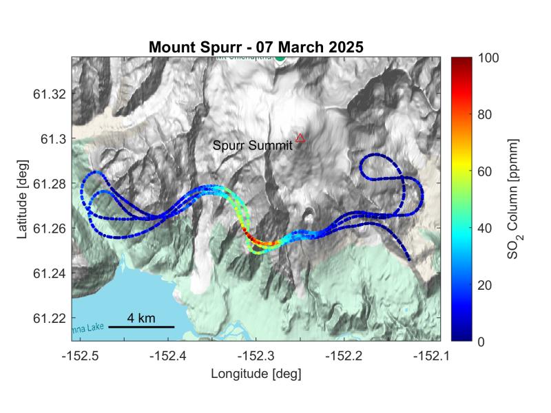
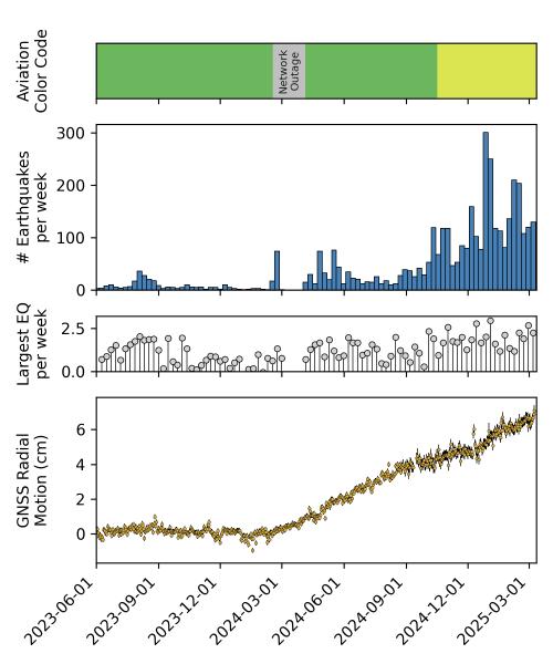
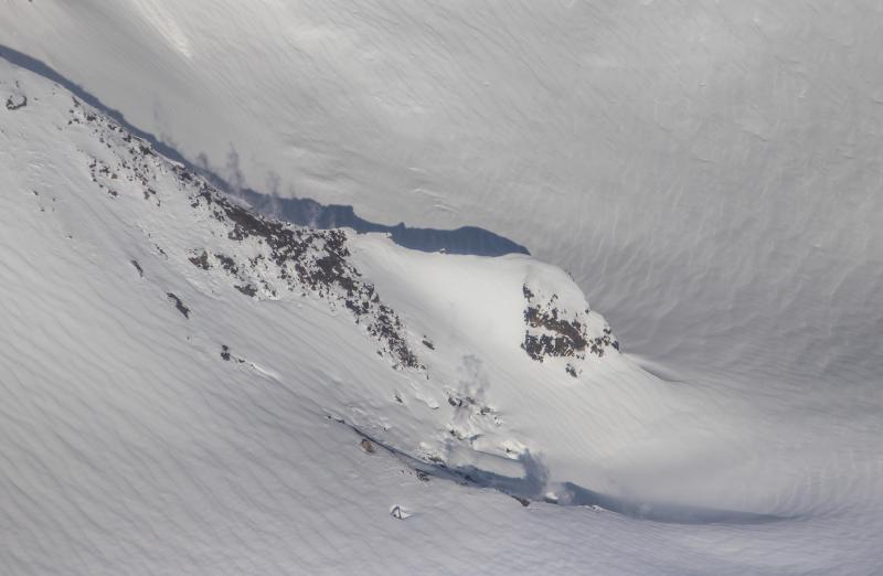
Excerpt:  “During overflights on March 7 and 11, AVO measured significantly elevated volcanic gas emissions from Mount Spurr volcano. Newly reactivated fumaroles (gas vents) were also seen at the volcano’s Crater Peak vent. Elevated earthquake activity and ground deformation continue. The increase in gas emissions confirms that new magma has intruded into the Earth’s crust beneath the volcano and indicates that an eruption is likely, but not certain, to occur within the next few weeks or months. The most likely outcome of the current unrest is an explosive eruption (or eruptions) like those that occurred in 1953 and 1992. Those eruptions each lasted a few hours and produced ash clouds that were carried downwind for hundreds of miles and minor ashfall (up to about ¼ inch) on southcentral Alaska communities. We expect to see further increases in seismic activity, gas emissions, and surface heating prior to an eruption, if one were to occur. Such stronger unrest may provide days to weeks of additional warning.”

fact sheet (2 pages)
1741655010
Map showing the flight track of an airborne gas survey performed on March 7, 2025 at Mount Spurr. The colors indicate the total amount of sulfur dioxide above the aircraft as measured using an upwards looking spectrometer. The gas plume emitting from the summit of Mount Spurr was clearly detected drifting south of the active vent. Further analysis of the data yielded a sulfur dioxide emission rate of about 440 tons per day.
1741668314
summary of earthquake activity and deformation at Mount Spurr from June 1, 2023 to March 10, 2025. Top panel shows the Aviation Color Code at Mt. Spurr. Second panel plots the total number of earthquakes located per week within 25 km of Mt. Spurr. The gray circles in the third panel show the magnitude of the largest earthquake recorded each week. The bottom shows the daily outward motion in cm from Mt. Spurr as measured at GNSS station SPBG.
1741638892
Map showing all earthquakes recorded within 25 km of Mt Spurr during the current unrest period from April 1, 2024 to March 7, 2025. Earthquakes within the past week (Feb March 1–7, 2025) are highlighted in blue. Circles are scaled by earthquake magnitude.